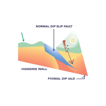
Normal dip slip fault illustration for understanding geological features and processes

Normal dip slip fault illustration provides insight into geological formations and tectonic activity. Understanding these faults is crucial for geologists. By studying various types of faults, including normal dip slip fault, we can better comprehend earth movements and their impacts. This knowledge helps in predicting geological phenomena and enhancing safety measures for structures in affected areas.

A winter landscape is covered in a thick blanket of snow, creating a serene and tranquil setting. In the foreground, there is a clearly marked dip slip fault in the snow, revealing a distinct displacement between two sections of the ground. The fault line runs diagonally across the landscape, with one side slightly lower than the other. The surrounding snow is untouched, with gentle snowdrifts forming soft curves. In the background, snow-laden trees stand tall, their branches heavy with white powder, and a pale gray sky looms overhead, hinting at the coldness of the winter day.A modern pastel illustration depicting an urban planning meeting taking place around a large conference table. The table is covered with blueprints of city layouts, showing various building placements. Several professionals are seated, engaged in discussion, with one pointing at a detailed map highlighting a "normal dip slip fault" in the area. There are laptops open, notebooks filled with notes, and coffee cups scattered around. A large screen behind them displays a 3D model of the proposed buildings in relation to the fault line, emphasizing their strategic placement for safety.A cross-sectional view of a normal dip slip fault is shown. The diagram features two blocks of earth: the hanging wall block is sliding downwards relative to the footwall block. The fault plane is clearly illustrated, positioned at an angle, indicating the direction of movement. There are arrows on the hanging wall block pointing downward to signify the movement. Text labels are included, with "Hanging Wall" near the upper block and "Footwall" near the lower block. Another label reads "Normal Dip Slip Fault" at the top of the diagram. The background is plain to enhance the clarity of the diagram.A mountain range is prominently displayed, featuring rugged peaks and valleys. The topographical landscape shows visible normal dip slip faults, with distinct geological layers exposed along the fault lines. These faults create unique features, such as steep cliffs and elongated troughs, which add depth to the terrain. Towering mountains rise sharply in the background, contrasted by lower, eroded hills in the foreground. The overall scene captures the dramatic interplay of geological forces that shape the mountains over time.
Nothing found in the community